
Hiking
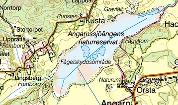
When you stay in the Pearl Cottage it's very easy to get wonderful nature experiences by hiking. From the cottage, it takes 10 min by foot to the forest. If you take the car (10 min) or bike (25 min), you have the nature reserve Bogesund with plenty of trails. Add 15 min by car and you get to the nature reserve Angarnssjöängen. Click on the maps below to get them bigger.
In Stockholm, you've the lovely island Djurgården with attractions and a network of easy-walking gravel footpaths.
Do mind the Swedish "right of public access" – and obligations – when you're out on a hike. If you need to, you can borrow back-packs, 1–2 trekking poles, thermos, plastic plates, and cups.
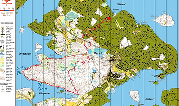
The Trail "Killingen" on Resarö
The forest "Killingen" on Resarö has spruces and pines but also a rich element of deciduous trees and a lot of hazel bushes. The trail here runs along the sea and to the southwest there are nice cliffs to swim from. Do bring a pick-nick and sit on the cliffs. Here, it’s very nice to watch the sunset. The distance around the marked trail on the map is about 7 km, but you can make it shorter by walking on the dotted trail from the west where it says "swim" on the map, just cutting the "cape" in the middle.
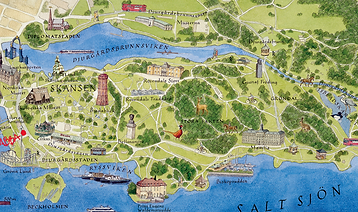
The Island Djurgården in Stockholm
Djurgården is one of Stockholm's most popular places to visit so you'll not be almost alone as the other hikes. The footpath around the island (9,5 km) runs along beaches, sometimes among large deciduous trees, sometimes more openly, but always in a park environment and almost exclusively on wide, gravel footpaths.
The views on the opposite side of the island are varied. Also, there are a variety of attractions along the route so make time for stops. You can combine this walk with a visit to the Vasa and ABBA-museum (“Day 2 in Stockholm”) as well as two art galleries (“Art Galleries”). Though, each of these four visits will take around two hours depending on your interest in them. It’s well worth stopping at Rosendals Trädgårdscafé (“Swedish Fika”) for a lunch or fika unless you have a picnic with you.
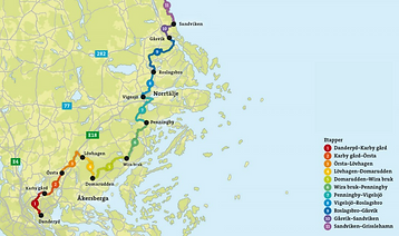
The Trail Roslagsleden
The trail Roslagsleden stretches 190 kilometres through the picturesque area of Roslagen, which is the name of the coastal areas north of Stockholm all the way up to the charming archipelago town Grisslehamn. The trail is part of the European Hiking Trail 6, also known as the E6, which runs from Turkey all the way to Finland. Roslagsleden goes through forests with terrain rich in ancient monuments (not only Vikings). The contrasts are great from the open landscape views to the hike along the coast with cliffs, sand and pebbles.
The trail is easy to get to and from – many people take the bus to the stages and then hike for an evening or a weekend. The stages are 9–25 km long (3–8 hours of hiking per day). Water/food is sometimes available along the way to fill up, but preferably bring a picnic if you are only planning one stage during a day.
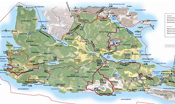
The Nature Reserve Bogesund
On Bogesundslandet you can hike on mile-long paths along beaches, coniferous and deciduous forests, oak hills, and meadows to places with traces from the time when the Vikings Gunne and Åsa lived here. We recommend Askrikerundan (6 km) or the longer Frösviksrundan (7 km). If you hike Frösviks-rundan, don't miss Kvarnberget (the Hill of the Mill). To this hill, do bring a picknick and enjoy the view. To the hill, you have to turn off the main trail where a small sign is that is easy to miss. To reach the trails, you need a car or a bike.
The Trail Angarnssjöängen
The nature reserve Angarnssjöängen (from 1992) is one of Sweden's best bird habitats. Also, there is a trail (6,5 km) around the lake (inclusive the walk from the parking it’s 9 km). In the southeast side of the lake meadow (north of Örsta farm) you have Midsommarberget (Midsummer Hill) where it’s nice to have a picknick.
The nature reserve is very rich in ancient monuments. They can often be dated from the period between the Bronze Age and the Late Iron Age, around 1500 BC–1000 AC. The most famous ancient monument is the rock carving northeast of Örsta farm. It was probably made around 1000 BC and gives an interesting picture of how people lived during the Bronze Age. You reach the trail by car (description on “Birdwatching”).
The Equipment
To know what to wear and with you, you need to know what to do. Start by thinking about what type of hike you intend to embark on (how long, distance, difficulty) and what the conditions will be (weather and season). There is not much difference in how much equipment you need for a full-day or half-day hike (except for the amount of food and drink you want to take with you). Choosing equipment for a multi-days hike requires more planning and you may need to buy, borrow, or rent equipment.
Necessary equipment for a half-day or full-day hike is:
-
A good pair of shoes that are suitable for the terrain and how fit you are.
-
A suitable backpack that you fill with:
-
a water bottle and food depending on how long you are out for
-
a plastic bag for rubbish and seat pad for the break
-
extra garments for heat and/or rain
-
sunglasses, -hat, and -cream
-
first-aid-kit such as a small scissor, plasters, wound rinse, and insect repellent.
-
-
How to find where you are:
-
a mobile phone with an electronic map
-
a backup physical map in case the power runs out in the mobile
-
a waterproof bag for the physical map and mobile
-
a compass if you're hiking “off-trail”
-
if you hike "off-trail" – tell someone where you intend to hike and when you intend to be back.
-
-
Not nececarry but nice: trekking poles and binoculars.
We have some equipment that you might borrow.
